Profile
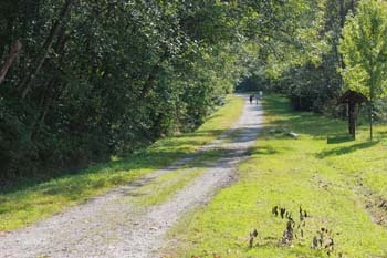
Bert Flinn Park was formed as a result of a referendum in 1999. Largely undeveloped, the park has an extensive trail system for hikers and mountain bikers. Most trails are unmarked, so users should exercise caution when traveling on unfamiliar trails.
An off-leash dog walk is located on the gravel right-of-way west of the Heritage Mountain Blvd / David Ave roundabout. Dogs must be leashed on trails beyond this gravel roadway.
The park is home to many bird and animal species including bear, raccoon, coyote and barred owls. Wetlands located at the north end of the park along the gasline right-of-way are home to many pond creatures including red-legged frogs and Northwestern salamander.
Many of the trails are old logging roadbeds: look closely to see evidence of this industry which flourished here in the early 1900s. Logged skid roads and old campsite artifacts can be seen in several locations in the park.
Park Size 126 Hectares
Question 1.
How can someone access the southern trails of Bert Flinn Park?
Accessing the Southern Trails of Bert Flinn Park
Venturing onto the southern trails of Bert Flinn Park involves a few straightforward steps. Here’s a clear guide to help you navigate:
- Starting Point:Begin at the junction just before reaching a clearing with a wide trail.
- First Move:Turn right at this junction. As you continue, make sure to stay left when you encounter the second junction.
- Crossing the Gravel Clearing:Proceed straight through the gravel clearing. You’ll need to cross a wide gravel road and enter the forest on the opposite side.
- Alternative Route:If you prefer, stick to the wide trail for approximately 100 meters. Look for a split where another wide trail veers to the right and heads downhill. If you choose this path, keep an eye out for a clearing on your right and swiftly enter the forest trail on your left.
- Navigating Inside the Forest:Once inside the forest, stay left at the initial junction. At the second junction, take another left and head uphill. Continue until you find yourself behind a row of houses.
- Final Stages:Follow the trail along the houses until you reach their end. Then turn left to go up the hill, keeping the houses to your left side. Continue until you reach a road with a bench.
- Reaching the Starting Point:Cross this road and follow the trail on the other side, which gradually ascends to reconnect with the wide gravel trail near your starting point. Turn right to follow this route back to where your hike began.
This route offers a scenic and engaging way to explore the southern parts of Bert Flinn Park, ideal for both casual walkers and seasoned hikers. Enjoy the journey!
Question 2.
What natural features and scenery can be found on the trails in Bert Flinn Park?
Discover the Natural Beauty of Bert Flinn Park
Bert Flinn Park in Port Moody offers a tapestry of natural features and scenery, ideal for those seeking a tranquil escape into nature’s wonders. As you embark on the trails, you’re immediately enveloped by a verdant west coast forest. Towering cedars and Douglas firs create a canopy overhead, offering cool shade and a sense of serenity as you wander.
One of the highlights of the journey is the series of gentle streams that meander through the park. These streams, accompanied by the sound of flowing water, add a soothing backdrop to your hike. Raised boardwalks allow you to traverse the wetland areas without disturbing the delicate ecosystem, providing a unique perspective of the park’s varied habitats.
As you navigate the trails, the gentle uphill climb reveals breathtaking vistas at every turn. You’ll cross quaint wooden bridges that enhance the trail’s charm and lead you to clearings where the forest opens up, offering a panoramic view of the surrounding landscape. In one part of the path, the trail gracefully circles around wetlands, giving you an intimate glimpse of the park’s biodiversity.
Whether you’re a local, a dog walker, or a nature enthusiast, the trails of Bert Flinn Park promise a delightful journey through some of the region’s most picturesque natural settings.
Question 3.
What are the trail details for Bert Flinn Park?
Trail Details for Bert Flinn Park
Difficulty: Easy
Time Commitment: Approximately 1 hour
Distance: 2.6 km round-trip
Elevation Gain: 40 meters
Seasonal Information
- Open: Throughout the year
- Camping Availability: Not permitted
Accessibility
- Proximity to Vancouver: A 40-minute drive
- Public Transit: Accessible by bus
Pet Policy
- Dog-Friendly: Yes, but dogs must be on a leash
Whether you’re a local or visiting from out of town, Bert Flinn Park offers a leisurely hike perfect for a quick nature escape.
Question 4.
Are there other hiking trails available in the Tri Cities Region near Bert Flinn Park?
Exploring Additional Hiking Trails Near Bert Flinn Park
Looking to extend your outdoor adventures beyond Bert Flinn Park? The Tri Cities Region offers a wealth of options for hiking enthusiasts. Here’s a closer look at some fantastic trails you won’t want to miss:
Shoreline Trail
This picturesque trail offers a delightful walk along the water, perfect for those seeking a serene experience. The trail is relatively flat, making it accessible for all ages and skill levels.
Coquitlam Crunch
For those ready to elevate their fitness routine, the Coquitlam Crunch provides a challenging workout with rewarding views. A popular choice for locals, its stair-stepper-style path will test your endurance.
Crystal Falls
A hidden gem, Crystal Falls, invites hikers to enjoy a scenic trek through lush forested areas. The journey leads to a spectacular waterfall, perfect for a photo op or a refreshing break.
Sasamat Lake
For a blend of hiking and leisure, head over to Sasamat Lake. The trail around the lake offers beautiful nature views and an opportunity for a swim during warmer months. It’s ideal for families and picnic enthusiasts.
These trails, each with their unique charm and level of difficulty, ensure that there’s always a new adventure awaiting in the Tri Cities. Happy hiking!
Question 5.
What should hikers expect when taking the longer route in Bert Flinn Park?
What to Expect on the Longer Route in Bert Flinn Park
Exploring the southern trails of Bert Flinn Park offers hikers a beautiful adventure filled with varied landscapes and a few challenges along the way. If you’re planning to take the longer route, here’s what you can anticipate:
Scenic Yet Unmarked Paths
- Tranquil Beauty: These trails showcase the natural beauty of the park, providing a serene escape into nature.
- Navigational Challenges: While the scenery is captivating, be prepared for unmarked paths. This can make navigation slightly tricky, adding an element of adventure to your hike.
Getting Started
- Choose Your Path Wisely: At the initial junction before the clearing with the wide trail, veer right. Keep left at the subsequent junction until you reach a gravel clearing.
- Cross and Enter: Pass straight through the gravel clearing, cross a wide gravel road, and enter the forest on the opposite side.
Alternative Entry
- Wide Trail Option: Continue on the wide trail for about 100 meters. When another wide trail branches off to the right, take it downhill. Remain observant for a clearing to your right, and make a quick entrance to the left into the trail.
Navigating the Forest
- Forest Trek: Once inside the forest, stay left at the first junction. At the second junction, go left again and head uphill.
- Residential Markers: The trail will eventually bring you behind a row of houses. Follow along until the end of the houses, then veer left up the hill with the houses on your left side.
Finishing the Loop
- Road Crossing: As the trail leads to a road with a bench, cross here and continue uphill on the trail opposite.
- Return Path: You’ll meet the wide gravel trail near your starting point. From here, turn right and follow this path back to the beginning.
Tips for a Successful Hike
- Plan Ahead: Since the trails lack marked signage, ensure you have a reliable map or a navigation app on hand.
- Stay Alert: Keep an eye on the trail and be ready for unexpected turns or junctions to avoid getting off course.
- Enjoy the Journey: Take in the beautiful surroundings and embrace the challenge of finding your way through the park’s more remote paths.
Embarking on this longer route requires a blend of curiosity and attentiveness. With a little preparation, you can fully enjoy the natural wonder that Bert Flinn Park has to offer.
Question 6.
How can someone reach Bert Flinn Park using public transit from downtown Vancouver?
How to Reach Bert Flinn Park Using Public Transit from Downtown Vancouver
To journey from downtown Vancouver to Bert Flinn Park using public transit, follow these steps:
- Start Your SkyTrain Journey
- Board the SkyTrain: Head to any station where you can catch either the Expo Line or the Millennium Line heading east.
- Transfer at Commercial–Broadway: Disembark at Commercial–Broadway Station.
- Switch to the Evergreen Line
- Transfer Platforms: At Commercial–Broadway Station, switch to the Evergreen Line. Look for a train destined for Lafarge Lake–Douglas.
- Exit at Moody Centre: Stay aboard the Evergreen Line until you reach Moody Centre Station.
- Continue by Bus
- Catch Bus #183: From Moody Centre, find Bus #183 which travels between Moody Centre Station and Coquitlam Central Station.
- Get Off at David Avenue: Ride the bus until the stop along David Avenue, just past the roundabout (stop #58889).
- Final Walk to Bert Flinn Park
- Walk to the Trailhead: Once you disembark, walk approximately 350 meters westbound along David Avenue, heading toward the roundabout. You’ll find the park’s trails beginning here.
By following this itinerary, you’ll navigate seamlessly from city streets to the natural trails of Bert Flinn Park. Enjoy your adventure!
Question 7.
Are there easier trails to follow in Bert Flinn Park, and where are they located?
Yes, Bert Flinn Park offers several accessible trails for those seeking an easier hiking experience. You will find that the simplest paths to navigate are situated in the northern section of the park. These trails are well-marked, ensuring a pleasant and straightforward journey through the natural surroundings.
Question 8.
Is Bert Flinn Park accessible by public transit?
Is Bert Flinn Park Accessible by Public Transit?
Yes, Bert Flinn Park is accessible by public transit. Here’s a step-by-step guide to get you there:
- Starting in Downtown Vancouver: Begin your journey by taking either the Expo or Millennium Skytrain line heading east.
- Transition at Commercial/Broadway Station: When you reach the Commercial/Broadway Station, switch over to the Evergreen Line.
- Ride to Moody Centre: Stay onboard the Evergreen Line and disembark at the Moody Centre Station.
- Hop on a Bus: At Moody Centre, transfer to Bus #183, which travels between Moody Centre Station and Coquitlam Central Station.
- Final Stop on David Avenue: Exit the bus shortly after the roundabout on David Avenue (stop #58889).
- Walk to the Park: From the bus stop, walk approximately 350 meters back along David Avenue towards the roundabout. You’ll find the park’s trailhead where the trails for Bert Flinn Park start.
This route offers a convenient and environmentally friendly option for accessing the natural beauty of Bert Flinn Park.
Question 9.
What is the round-trip distance of the trail at Bert Flinn Park?
The round-trip distance of the trail at Bert Flinn Park is 2.6 kilometers.
Question 10.
How difficult is the hike at Bert Flinn Park?
How Challenging is the Hike at Bert Flinn Park?
Bert Flinn Park offers a hiking experience that’s accessible to most. The trails are generally considered easy, making them perfect for those who enjoy a leisurely walk in nature without too much physical strain.
What to Expect:
- Trail Terrain: The paths are well-maintained and feature gentle inclines, suitable for all age groups and fitness levels.
- Duration: Expect to spend a couple of hours enjoying the scenery, depending on your pace and chosen route.
- Skill Level: Beginners and casual hikers will find the trails accommodating, while still enjoying the beauty of the surrounding forested area.
Ideal For:
- Families with children
- Casual hikers looking for a day out
- Anyone seeking a pleasant outdoor excursion without rigorous effort
For a peaceful and enjoyable hike without the challenge of steep climbs, Bert Flinn Park is an excellent choice. It’s a serene spot to connect with nature and experience the outdoors.
Question 11.
What directions should be followed to reach Bert Flinn Park by driving?
Directions to Bert Flinn Park by Car
Estimated Driving Time from Vancouver: Approximately 40 minutes
Navigating your way to Bert Flinn Park in Port Moody is straightforward and will lead you to a local gem filled with picturesque trails. Here’s how to get there:
- Start from Vancouver:
- Head east on Trans-Canada Highway 1, making your way out of the city.
- Exit onto Barnet Highway:
- Take exit 44 for Barnet Highway/BC-7A toward Port Moody.
- Follow Barnet Highway:
- Continue on Barnet Highway through Burnaby and into Port Moody. Along the way, you’ll enjoy views of Burrard Inlet.
- Turn onto Ioco Road:
- Once in Port Moody, look for the exit onto Ioco Road. This road will take you through a blend of scenic urban and forested areas.
- Continue on Ioco Road:
- Drive along Ioco Road for a few kilometers, observing local landmarks such as the Port Moody Recreation Centre.
- Turn onto Heritage Mountain Boulevard:
- As you approach the hills, turn left onto Heritage Mountain Boulevard. This will lead you closer to your destination.
- Left onto David Avenue:
- Continue on Heritage Mountain Boulevard and turn left onto David Avenue. You will soon see signage for the park.
- Arrive at Bert Flinn Park:
- Look for parking options near the roundabout at David Avenue and Heritage Mountain Boulevard. The park entrance is just a short walk from here.
Once parked, you’ll find yourself ready to explore the beauty and tranquility of Bert Flinn Park, surrounded by majestic cedars and Douglas firs. Enjoy your hike!
Question 12.
What is the elevation gain on the Bert Flinn Park trail?
The Bert Flinn Park trail offers a moderate elevation gain of approximately 40 meters. This makes it an ideal choice for hikers seeking a gentle ascent suitable for a relaxed outing. Perfect for families and beginners, the trail provides a pleasant combination of exercise and scenic views without being too challenging.
Question 13.
How long does it take to complete the hike at Bert Flinn Park?
How Long Does It Take to Complete the Hike at Bert Flinn Park?
Embarking on a nature walk at Bert Flinn Park is a delightful way to spend your time without committing your entire day. Here’s a quick breakdown of what to expect:
- Duration: The hike typically takes about one hour to complete, making it an ideal choice for a quick nature escape.
- Distance: This round-trip trek covers approximately 2.6 kilometers.
- Effort Level: With an elevation gain of just 40 meters, the hike is rated as easy. It’s accessible for all skill levels, providing a relaxing way to enjoy the outdoors.
Additional Details
- Accessibility: Located just 40 minutes from downtown Vancouver, you’ve got a convenient getaway at your doorstep. Plus, public transport options are available for easy access.
- Dog-Friendly: Feel free to bring your furry friend along, as dogs are welcome on-leash.
- Seasons: Open year-round, this trail is a dependable choice for any season.
Pack your hiking boots, perhaps a light snack, and embrace the simplicity of this quick yet rewarding outdoor experience.
Question 14.
Are there toilet facilities available at Bert Flinn Park?
Facilities at Bert Flinn Park
If you’re planning a visit to Bert Flinn Park, it’s important to know that the park does not have restroom facilities. Visitors should plan accordingly and be prepared to use alternative options before or after their time in the park. Whether you’re exploring the trails or enjoying the natural surroundings, be aware of this limitation to ensure a comfortable experience.
Question 15.
How far is Bert Flinn Park from Vancouver?
How Far is Bert Flinn Park from Vancouver?
If you’re planning a visit to Bert Flinn Park, you’ll be pleased to know it’s conveniently located near Vancouver. The journey is generally straightforward and takes approximately 40 minutes by car, depending on traffic conditions.
Driving Directions:
- Start your journey from Vancouver: Head east on Highway 1, also known as the Trans-Canada Highway.
- Take the exit toward Port Moody/Coquitlam: This will guide you into the scenic Tri-Cities area.
- Follow the signs to Bert Flinn Park: The park is nestled in the lush landscapes of Port Moody, known for its trail networks perfect for hiking and cycling.
For those opting for public transportation, consider taking the SkyTrain’s Evergreen Extension to the Moody Centre Station, followed by a local bus or a short taxi ride to reach the park.
Whether you’re driving or using public transit, Bert Flinn Park offers a quick escape from the city, inviting you to enjoy its serene natural beauty just a short distance from Vancouver.
Question 16.
Is Bert Flinn Park open year-round?
Yes, Bert Flinn Park is open throughout the year. You can enjoy its trails and natural beauty in any season, offering a perfect retreat no matter when you visit. Whether you’re hiking in the spring, enjoying a summer stroll, admiring the fall foliage, or exploring in the winter, the park remains accessible year-round.
Question 17.
Is camping allowed at Bert Flinn Park?
Can You Camp at Bert Flinn Park?
If you’re planning a camping trip and are eyeing Bert Flinn Park as a potential spot, you’ll need to reconsider. While Bert Flinn Park offers beautiful trails and a chance to enjoy nature, it is not a location where camping is permitted.
Instead, if camping is what you’re seeking, you might want to explore other nearby parks or dedicated campgrounds that cater to overnight stays. These places often provide the necessary amenities and have official approval for setting up your tent under the stars.
For an enjoyable visit, consider hiking or exploring the park during the day, then head to a suitable camping site nearby for your overnight adventure.
Map
Sorry, no records were found. Please adjust your search criteria and try again.
Sorry, unable to load the Maps API.


